 One of the joys of traveling is heading off with enough time to get lost. Okay, so I have to be in Montreal in two weeks, but all I have to do today is head sort of north. I didn’t even turn on my GPS as we left Amarillo.
We stopped on a whim a couple of times so Mary Ann could take pictures, and the only time we really wanted a map was trying to decide what towns were likely stopping places for the night, and to find the Walmart to buy groceries and an ice chest.
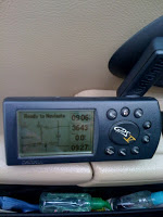
Two things made me realize what a wealth of mapping tools I have these days. My iPhone has a wonderful GPS enabled map system at hand. Unfortunately, the only built-in maps are a continent-scale map at the big end of the zoom and whatever is left in the cache at the close up ranges. So when cruising along in the panhandle of Oklahoma with no cell coverage, the iPhone map was not useful. Mary Ann picked up my GPS V, shown above, and turned it on. She’d never used it extensively, so I told her which button to push to turn it on and warned her of the delays it took acquiring satellites. She was a little frustrated using the buttons. No touch screen.
But the GPSV has wonderful built-in maps at the highway and major city roads level, and doesn’t need any kind of internet. It’s the one GPS I would take in an emergency, like when we were in Hurricane Ike and all the networks were down for days.
But even with iPhone to get the street address of the Walmart and the Garmin GPS V when we’re out of signal range, we still need one more thing.
An old-fashioned road atlas printed on huge pages. You see, we don’t know where we’re going, and if the past is any guide, we’re likely to pass five miles away from some scenic adventure and never realize it’s there for us. The iPhone is wonderful, but the palm-sized screen has to skimp on details. There’s a reason those atlases were printed large. You can see the big picture and the details in the same glance. Pocket gadgets just aren’t there yet.