I’ve been watching the Central Texas bats on radar for some time now, so I’ve grown quite familiar with their patterns and know when they appear. A couple of times now, I’ve seen one of the downsides of the bats-on-radar. As actual real thunderstorms begin to move into the area, the computerized storm track detectors that filter the Nexrad radar signals and try to make sense out of them get confused.
It happened again tonight, and I was quick enough on the screen capture keystrokes to catch the bogus signal before the real weather people removed it. In the image above, that greenish patch around the Austin area is ‘mostly’ bats. There are some clouds running from Waco through Bryan that are real moisture with water droplets in them. But the rest of that patch running Round Rock to San Antonio is a bat signal.
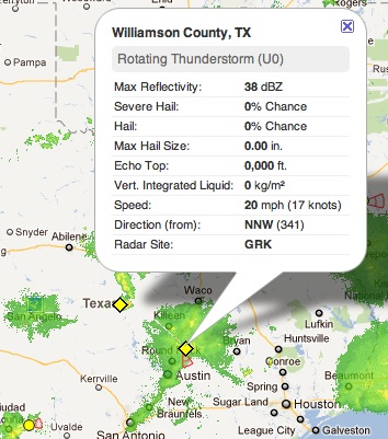
The danger is that we have to put up with such false positive alerts because of the real ones. See that diamond shape half-way between Austin and Abilene? That’s a real thunderstorm.
Here’s a different look at the same radar signal seen through the RadarScope program. Because I’ve been watching the radar all day long (it’s my ‘screen saver’ on my media server), I knew what was bats and what was weather, but it’s not obvious from one screen image. And it certainly wasn’t obvious to the Nexrad computer system.
